Galileo is my favorite GPS moving map for driving unfamiliar roads. It’s installed on my iPad, which is much easier to carry and charge in the car than a laptop GPS system.
Here are a few pros and cons to this application, as well as a comparison to ForeFlight and Apple Maps. Why these three choices? Among the many mapping applications I’ve looked at and tried out, these are the only three I still have on my iPad.
Pros:
- Quick start up.
- Fast and smooth panning and zooming.
- Intuitive map caching.
- Try before you buy. All except a few features work in the free version.
- Uses the best maps, and you can edit them if they need changes.
Cons:
- It’s not a full-featured GPS, so no offline searches or driving directions.
- It is missing a much-needed speedometer and compass display.
- There’s no way to refresh specific parts of the map, except to delete the whole thing.
I was asked my opinion about this application as a pilot, so I also took a quick look at its aviation capabilities. Galileo is by no means an EFB provider, but I suppose it is a reasonable choice if someone just needs a free moving map. There is a steep trade-off of money for time, though. To get the U.S. aviation charts loaded, I had to run an extra program on my desktop called MOBAC and then select a set of files to download from ChartBundle.com. This MOBAC thing is awkward, time consuming, and extremely error prone.
There are two advantages I can see where Galileo outperforms ForeFlight:
- Galileo has far better panning and zooming.
- Galileo offers GPS track recording.
Just to note a shortcut I found for the Galileo map import procedure; it is not necessary to use iTunes. I am not an iTunes user and I was happy to avoid it. When importing custom maps, the files can be copied through SuperFiles, Safari, OPlayer, or any other application that can transfer files into Galileo.
| Feature | Galileo | ForeFlight | Apple |
|---|---|---|---|
| OpenStreetMap (Standard) | Yes | No | No |
| OpenStreetMap (Foreflight) | No | Yes | No |
| OpenStreetMap (Cycle Map) | Yes | No | No |
| OpenStreetMap (MapQuest) | Yes | No | No |
| Apple Map | No | No | Yes |
| Satellite Map | No | No | Yes |
| User Can Update Street Maps | Yes | Stale | No |
| Offline Street Maps | Yes | Yes | Yes |
| Cache Erase | Yes | No | No |
| Cache Selective Refresh | No | No | No |
| Maximum Zoom | 18 | 16 | 19 |
| Pan & Zoom | Fast | Delayed | Fast |
| Map Import | Yes ($) | No | No |
| GPS Tracking | Yes | Yes | Yes |
| External GPS Support | Yes | Yes | Yes |
| GPS Recording | Yes ($) | No | No |
| Speed Display | No | Yes | No |
| Altitude Display | No | Yes | No |
| Distance Measuring | No | Yes | No |
| Pushpins | Yes ($) | Yes | Yes |
| Route Planning | No | Yes | Yes |
| Driving Directions | No | No | Yes |
| Spoken Directions | No | No | Yes |
| Construction Information | No | No | Yes |
| Traffic Information | No | No | No |
| Online Business Search | Yes | No | Yes |
| Offline Business Search | No | No | No |
| Find Nearby | No | Yes | Yes |
| U.S.A. Aviation Features | |||
| Sectional Charts | Import | Yes ($) | No |
| IFR Charts | Import | Yes ($) | No |
| d-TPP | No | Yes ($) | No |
| d-A/FD | No | Yes | No |
| Weather | No | Yes | No |
| NOTAMs | No | Yes | No |
| Automatic Chart Updates | No | Yes ($) | No |
| Expired Charts Warning | No | Yes | No |
| Online Airport Search | Yes | Yes | No |
| Offline Airport Search | No | Yes | No |


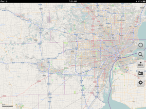
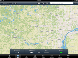
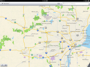
Galileo also offers some clear advantages aesthetically. As you can see in the screen shots, Apple has an appalling orange-on-yellow style for freeways. ForeFlight is even worse with its white-on-yellow color scheme. At certain zoom levels, the roads are nearly invisible. These are not the only faults with the maps. More problems become apparent at closer zoom levels.
ForeFlight seems to have an independent tile server set up to comply with the OpenStreetMap license, which includes the map data but not the map images. The street map data being used are at least several weeks old by my estimation, and there is no indication of that in the application. This is a bit of a surprise because ForeFlight goes to great lengths to display currency dates on all of the aviation charts.
Apple’s maps are horrendously incomplete compared to the OpenStreetMap data being used by Galileo and ForeFlight. In my city, Apple Maps shows nothing where roads should be, roads and railroads where there are none, and just a handful of random features.
Galileo is the clear winner for driving. Find it and try it out at Galileo-App.com.